A printable course chart with marks may be downloaded Course Chart Laminated copies are also available in the clubhouse.
Note The course chart was updated on July 14 2023 to correct some case errors ( mark F not f).
As we are now free of covid and bridge restriction so we are able to plan more varied courses than in the last few years. There are a few considerations:
- Maintain a selection of short courses for light winds and/or strong tides.
- Devise longer courses too and generate a few more options for the prevailing SW winds.
- Address the concern that with the new dredging west of the marina, it was 6m below datum for the bridge works, there will be stronger flows on the ebb tide by the west breakwater (not too bad on the flood tide though) Hence, a way of not having to pass the breakwater in a light wind and strong ebb tide is needed.
- In wind over tide conditions, the flows and waves at the marks by the central bridge pillar can be evil so if we use these, mark the courses as needing careful consideration.
- Keep using the white mooring buoy in N Queensferry, but to avoid confusion call it M. The yachts have a Mark M too but its somewhere far away so there won’t be any conflict.
The full set of available marks is:
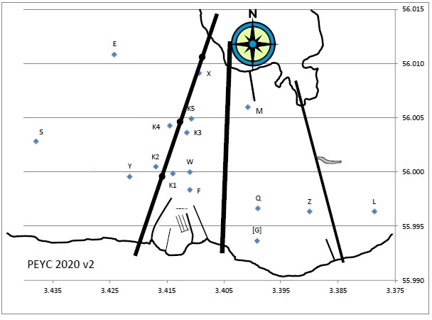
Where Kx are the remaining exclusion zone marks, but now with no restriction on which side they must be left.
The decisions about using these marks are:
- K1 and K2 are so skewed to the start line they will not be used as a first windward mark.
- Ignore K5. It is inadvisable to use it when approaching or leaving from the south and there are few options that would use it from the north.
- Use K4 from the west, K3 from the east to minimise time in the beamer rock tides.
- Caveat use of the courses including Kx with instructions to ask the rib to check the sea state at those marks.
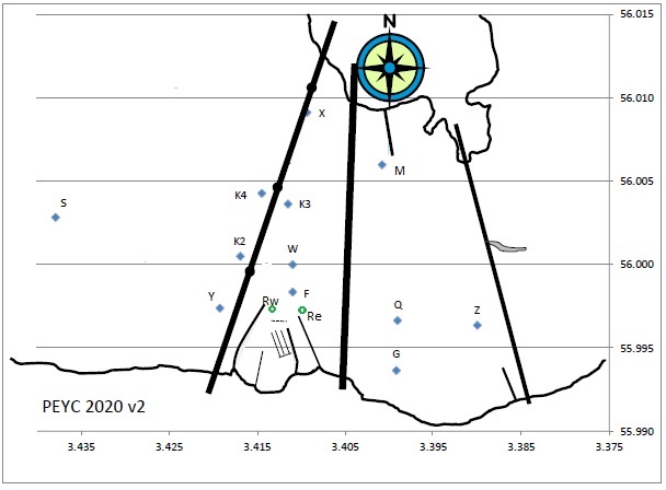
- The small green mark laid temporarily for the last few years has been useful to make short average lap courses. Now, it can be used as a roving mark, similar to how we have used it in the last few years, but on either side of the start/finish line. It will normally only be used as a leeward turning mark, only as a windward mark in light wind conditions.
- Mark S is a long way west, so courses that use it will be paired with using the green mark as a roving mark on the east so we don’t have to go all the way down the Q for a leeward mark.
The amended course chart then becomes:
Advice to OODs
The advice to OODs about using these courses is:
- Aim for average lap courses that allow 2 or 3 laps. If this means you need to use a course including the roving mark, ask the RIB crew to lay it.
- Longer courses mean more time waiting between races for boats to finish, so if you want to use a 3 mile course, select it for the last race that day.
- Look at the tide round the west breakwater, if it’s a problem (fast tide, light winds) use a course that includes the west roving mark rather than mark Y. Some shorter courses are duplicated to allow this with Rw substituting for Y
- Courses with both Y and G will make it hard for the RIB crew to monitor the race so use them in relatively benign conditions.
- If you use K2, K3 or K4, ask the rib crew to go have a look at the sea state first.